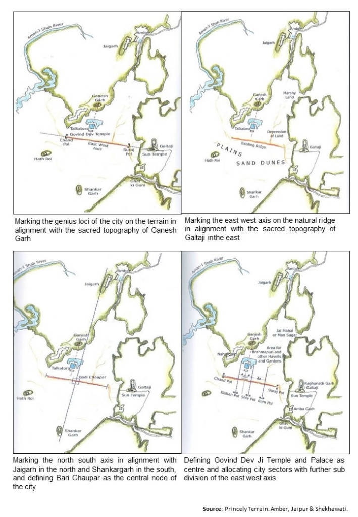
The basic spatial planning of a traditional settlement was guided by natural forces and topographical features. Jaipur is an 18th-century symbol of secular planning, a modern city designed to encourage trade and commerce and yet the primary feature in its planning is its response to the topography and the centric organization. Amber had served the capital of Dhoondhar and the city had expanded and by the beginning of the 18th century, it had become very congested. There was not much scope for expansion due to the existing hilly terrain and it was important that the new capital should be directly linked with Amber, the earlier seat of the Kachchawas. The physical constraints of the proposed site for the new capital included the hills on the north with Jaigarh Fort and the Amber Palace beyond and the hills on the east with the sacred Galtaji. Beyond the depression formed by the low- lying marshy lands on the northeast, there was a slight rise in terrain and a ridge running from the west to east inclined at 15 degrees towards the south. On the western edge were the hills of Nahargarh and the southern end was marked by a low hillock called Shankar Garh. The only existing landmark on this terrain was the Talkatora, a small water body and the hunting lodge used by the Kachchwas.
The town planning principles of Jaipur were not very different from those of the preceding cities in the region but it was its location on the plain that led to a practical adoption of the gridiron pattern on site. The planning of Jaipur is rooted in the centric Indian philosophy with the temple of Govind Devaji defining the centre that leads to the genesis of the city. The city was devoted to Govind Devaji with Sawai Jai Singh as his dewan or minister. Observing the ritual of demarcating the religious centre as the genius loci of the new city, it is evident that Jai Singh installed the image of Govind Deva as Jai Niwas in 1715 AD.
Conceptual sketches of Town Planning of Walled City of Jaipur, Source: Princely Terrain: Jaipur, Amer and Shekhawati
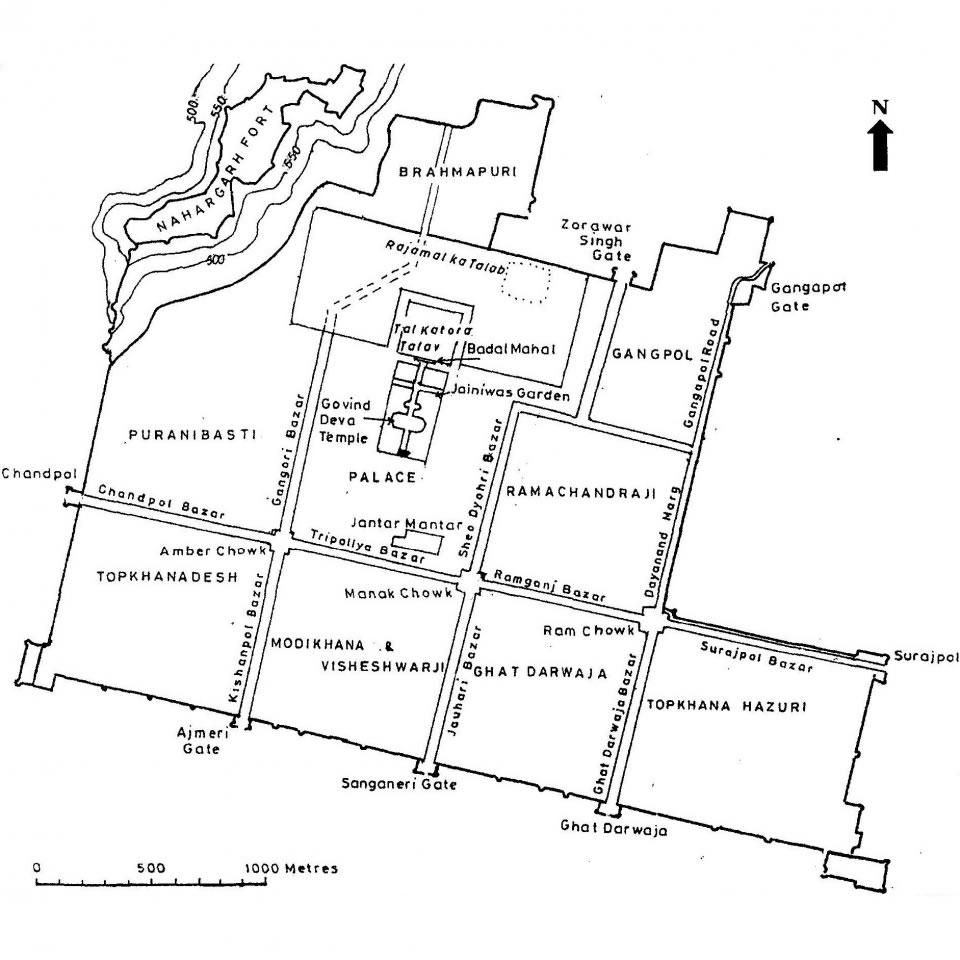
The basic plan of Jaipur was derived by marking the loci using the surrounding topography of the site. The centre of the nucleus of the city had already been established at the Jai Niwas with the installation of the idol of Govinda Deva. The main axes of the city were defined by the sacred site of Galtaji, an important pilgrimage centre since the 16th century, located on the eastern hillock. This axis was aligned 15 degrees to the northeast running along the natural ridge. Stretching in line with the Nahargarh Hill on the west, the ridge marked the main east-west axis with Surajpol at the eastern end and Chandpol at the western end. The north-south axis was marked in alignment with the Jaigarh Fort, the highest point in the north and the hillock of Shankar Garh (Moti Dungri Fort) in the south.
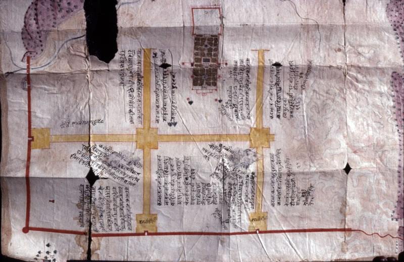
“Dated: 1727-34,Map Showing Instruction for Planning of First Four Chowkri and Bazars, Source: City Palace Museum, Jaipur”
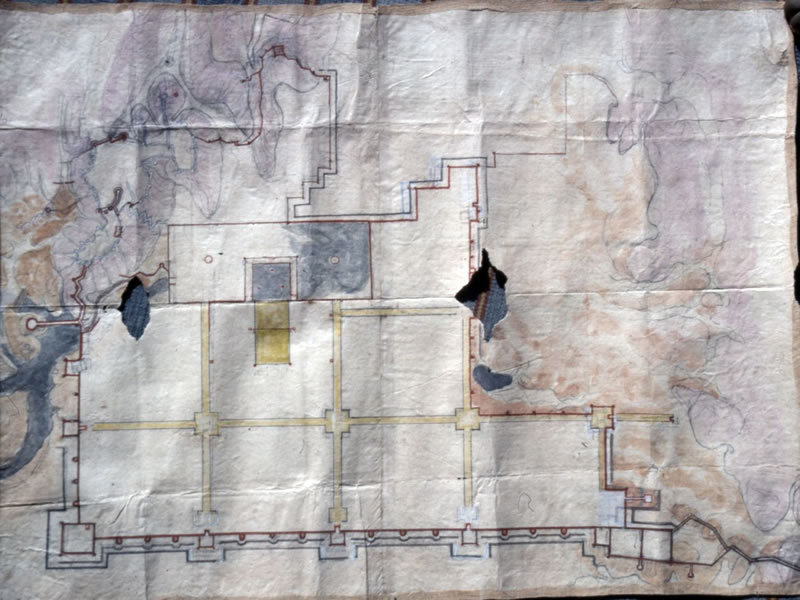
”1727-34, Map Showing Clear Wall Boundary for North Area and Works being executed by Sawai Jai Sing II, Source: City Palace Museum, Jaipur”
The east-west axis of the town was divided by three perpendicular roads. The crossing of the two cardinal axes defined the main public squares of the city called the Badi Chaupar or Manak Chowk. On the west, a road parallel to the north-south axis created the second town square called the Choti Chaupar or Amber Chowk and effectively placed the Palace Complex in the centre of the city. Another parallel road on the eastern side created the third public square called the Ram Ganj Chaupar or Ram Chowk. The intersecting axis divided the city into eight portions, with the central ones of equal size and the outer ones as per the remaining dimensions till the Chandpol in the west and Surajpol in the east.
”This partial map of the walled city is based on an earlier map of Jaipur that has been dated in the reign of Pratap Singh (1778-1803) by Gole (Indian Maps and Plan, pg 195)”
These three chaupars worked as the centres and sub-centres of further subdivision and structuring of Jaipur city. All the important temples and significant Havelis of the leading courtiers and merchants were marked on these chaupars and along the axis. The city was further divided into seven sectors or chowkris on either side of the axis with the eighth one in the northeast falling in a low lying, unusable area.
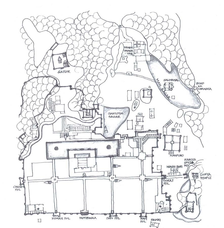
”Plan showing the location of Chowkris, Chupars and other major elements, Source: Unknown, Based on Havell 1911 and redrawn”
The present plan of the walled city shows seven city gates: Suraj Pol, Chand Pol, Shiv Pol, Kishan Pol, Ram Pol, Dhruv Pol and Ganga Pol. There are also other gates namely New Gate (earlier called the Chor Darwaza), Char Darwaza and Samrat Pol. The main markets, shops, Havelis and temples on the main streets were constructed by the state, ensuring uniformity of the street façade. There were approximately 400 temples built in the walled city during planning. Even today, the important temples can be observed at the four most important locations in the city along the cardinal axis.
The important temples with shikharas can be observed at the four most important locations in the city along the cardinal axes, i.e. the Laxmi Narayan Temple at Badi Chaupar, Rama Temple at Choti Chaupar, Murli Manohar Temple at Ramganj Chaupar and Kalka Temple opposite to the main Sireh Deodhi entrance of the Palace. In all these temples, the idol faces Govind Devaji, the main deity of Jaipur. Most of the temples inside the city were built in a haveli temple style without the shikhara except a few others like Surya temple, Ganesh Garh Temple etc.
”Map of Jaipur in the early 19th century, Source: City Palace Museum”
The land for the houses of important nobles was marked on the main streets and allocated as per caste, rank and financial status. Thus the main commercial streets had the primary purpose of trade with series of equal size shops and the urban façade was further enriched by punctures of entrances to Havelis and temples. The Havelis were medieval mansions belonging to the nobles serving the Rajput rulers and were clearly demarcated from the houses of the subordinates and the common people. The Havelis range from a single courtyard house from to an assemblage of multiple courts. In Jaipur, the number of courtyards in a haveli range from one to seven depending on the status of the owner or on the number of family members. Another unique feature of the city is its unique water system of underground canals that was designed for the water supply in the city and the square central tanks that were located in Badi Chaupar and Choti Chaupar.
Jaipur city planning was developed with specific dimensional norms and specific terms for measurements were used. ‘Sawaya’, a quarter extra is expressed in the complete planning and detail of Jaipur. Strict building by-laws were enforced to control the height of the buildings, the height of the ground floor etc. to maintain uniformity. The width of the main roads was 39 ¼ gaz (Gaz is the traditional unit of measurement in India. In Jaipur, 1 gaz equals 0.838 metres), secondary roads were half this size while the tertiary roads were a quarter of this dimension. The width of the square chaupars were three-time that of the main primary street, i.e. 117 ¾ gaz. Similar ‘sawaya’ terms were used for the measurement of courtyards, plots and rooms.
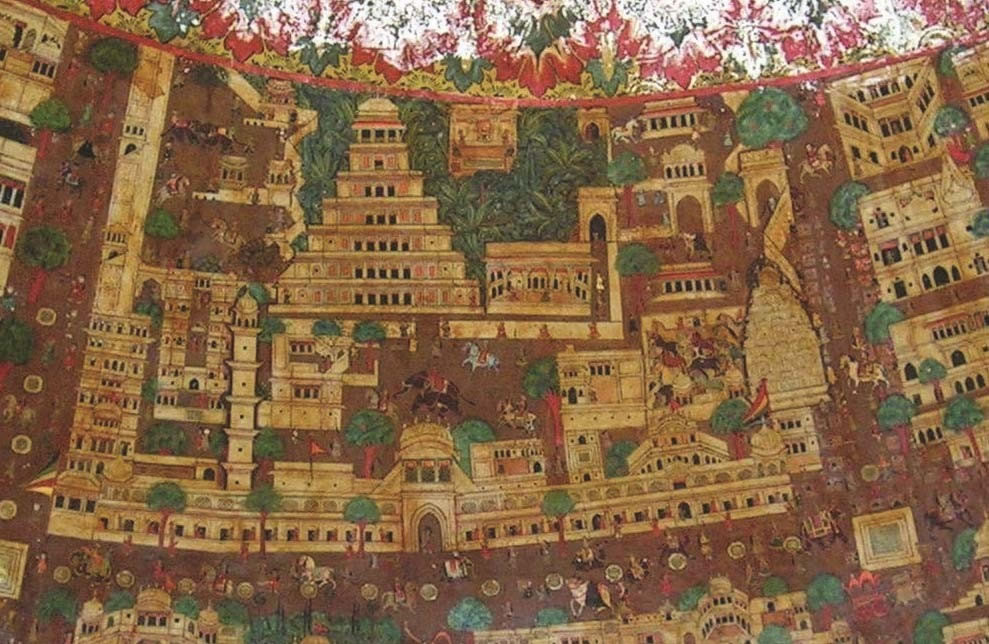
At the time when Jaipur was founded, three main structures already completed. These were Chandra Mahal as the political centre, Govind Mahal or Surya Mahal as the religious centre and Badal Mahal. Chandra Mahal is a seven storeyed structure in the City Palace complex, which was axially aligned to the south of the Govind Devaji temple. Between Chandra Mahal and Govind Mahal, a Landscaped Mughal garden was laid out. In charbagh pattern. The construction of the city and its surrounding walls was started on 18th November 1727 and in 1729, merchants were invited. By 1732, the construction of Govind Mahal, Brahmapuri, Badal Mahal, Rajamal ka Talab and Rajamal ki Haveli, Jaleb Chowk, Ram Chowk, Manak Chowk, Pahadgunj, Ramganj, Suraj pol, Shiv pol, Chand pol and Haveli of Pundrikji were complete.
Source: Indian Heritage Cities Network, Walking into the Microcosm of Jaipur, A Concept Paper, by UNESCO New Delhi. http://unesdoc.unesco.org/images/0019/001921/192113e.pdf